

Routes through the council
-
Go to Facebook
-
Go to X
-
Go to Instagram
-
Go to TikTok
ROUTES THROUGH THE COUNCIL
The weather in our municipality is an incentive for tourists. Mild winters and summers without heatwaves make Oviedo one of the favourite destinations for people fleeing from thermometers that reach forty degrees or collapse to below zero. Not here.
It is a popular saying, but true and a luxury for many of the people who visit us: Don't go out without a jacket in Oviedo. And an umbrella may come in handy if it is cloudy.
Indeed, the mild temperatures in the capital and in the region mean that tourism is not limited to any given season. For many people, spring or autumn are the best seasons to visit. Thanks to these mild weather conditions, the capital and the Principality boast a natural heritage that is unique in Spain, places that you will love and that, in many cases, can be visited on established routes. These are some of them:
Naranco Route
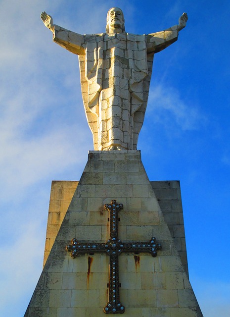
Overlooking Oviedo, we have the Naranco, an area measuring 5 kilometres around the city, where the highest point is El Pico Paisano, at an altitude of 632 metres. At the top is one of the most frequently visited and significant sculptures in Oviedo: Sagrado Corazón de Jesus (Sacred Heart of Jesus), visible from virtually any point in the capital. For centuries, this area has provided unique panoramic views and it is also home to the two great jewels of the Asturian pre-Romanesque, Santa Maria del Naranco and San Miguel de Lillo, as well as an interpretation centre for this early medieval artistic style. To reach this area on foot, you can walk along the Finish Track and other hiking routes. After an hour’s walk, the capital's buildings and wide streets are far behind and the city can now be viewed from a much better vantage point.
Senda Verde (Green Route) and Parque de Invierno (Winter Park)
The Green Route is also known as the Fuso Route or the Fuso de la Reina Route, which is the town at the end of this route that starts in Parque de Invierno and is almost eight kilometres long. It is suitable for hikers, cyclists, and walkers in general, as this is a paved path with no steep sections. This walk runs along the old railway line and, in fact, you will see the old La Manjoya Station along the way. There are remains of ancient mills and riverside forests in the last section. The path ends at the old train station of Fuso de la Reina, a town with an unmanned station from where you can return to Oviedo without having to walk back through Parque de Invierno, one of the largest parks in Oviedo covering more than one thousand square metres and with spectacular views of the Aramo Mountain Range. This park houses several municipal facilities, such as the Palacio de los Niños (Children's Palace), the San Lázaro swimming pools, a labyrinth formed by 650 laurel trees, a typical Asturian smallholding consisting of a house and an hórreo (granary), and a skate track.
Origin of the Primitive Way
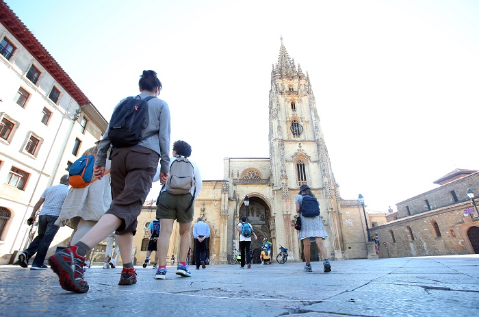
Oviedo, more specifically its Cathedral, marks the beginning of the Primitive Way to Santiago de Compostela. This is identified by a plaque, next to the Basilica, that marks the origin of the Way of St. James promoted by King Alfonso II the Chaste, the first person to complete the Way of Santiago in the 9th century starting from the Cathedral of Oviedo, which treasures the Holy Ark, with relics from Jerusalem, such as the Holy Shroud.
The Way crosses the city centre along Jovellanos, Covadonga, Melquiades Álvarez, Independencia and La Losa Streets, and the first stage ends in Grao, after passing through Las Regueras and other rural areas of our council, such as San Lázaro de Paniceres, Llapaxuga or Loriana.
Priañes and the Meanders of the Nora River
The “Meanders of the Nora” is a natural monument, a spot of great beauty together with a forest of chestnut trees along the banks of the river. This route, as in the case of the Naranco Route, allows hikers to visit the pre-Romanesque church of San Pedro de Nora or the Furacón Dam before reaching Priañes, where, next to a recreational area, you can make your way down to the Nora River after stopping for a while at the Meanders Viewpoint, located in the upper part of the village.
Guanga or Buanga Waterfalls
The Guanga waterfalls form one of the most beautiful natural landscapes in our council where the Buanga stream flows toward the Trubia River. These waterfalls are located in San Andrés, a parish of Trubia, which serves as the gateway to the Oso Valleys. In fact, from here you can access the Senda del Oso (Bear Trail), one of the great cycle tourist routes of Asturias. The Cascadas Route starts and ends at the old washhouse of San Andrés de Trubia, a town you can reach by car. You can park your car at this point, right at the beginning of the route